

Practical Surveying Laboratory
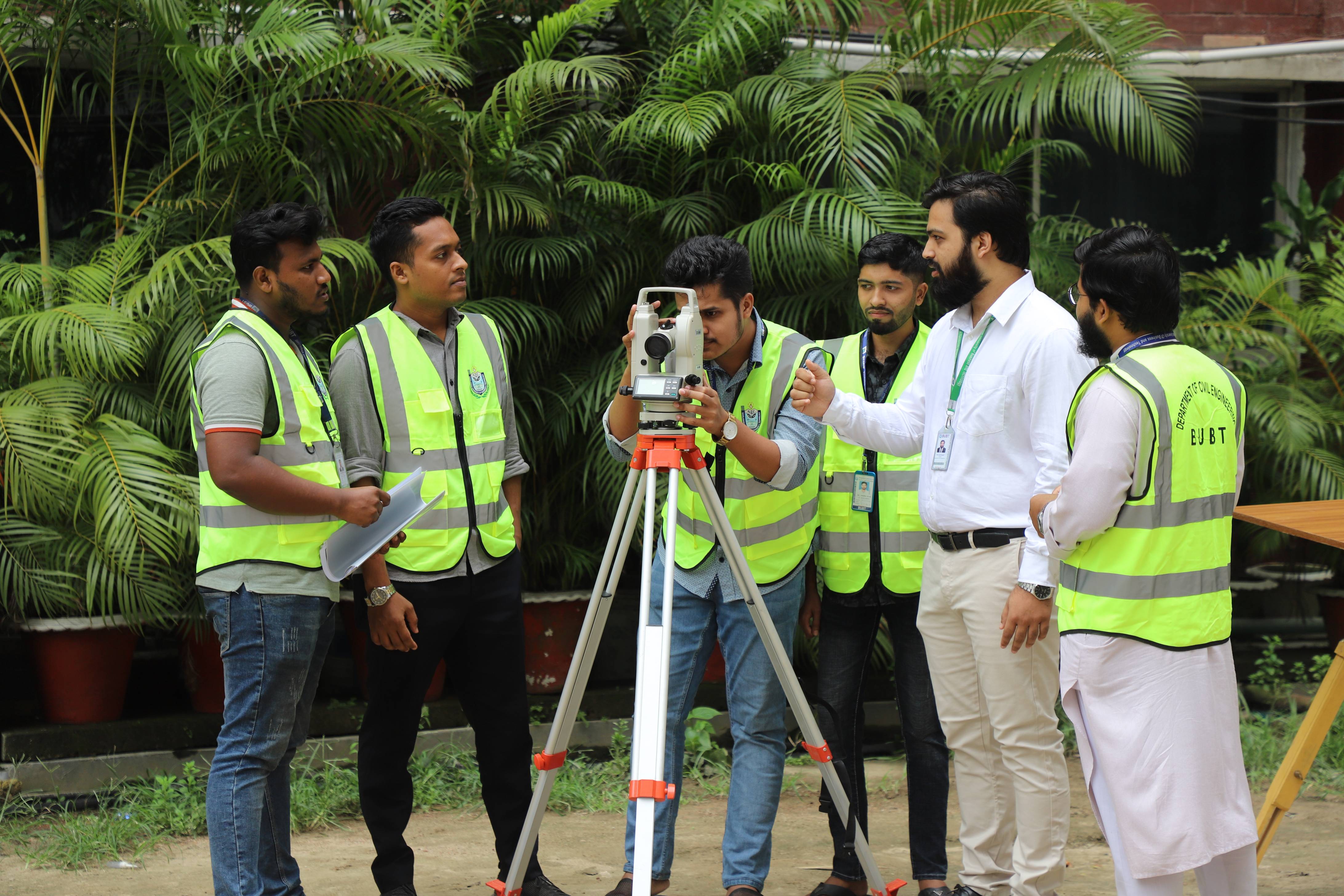
The **Practical Surveying Laboratory** at BUBT provides civil engineering students with hands-on training in land surveying and geomatics. Through experiments like contouring, levelling, and total station traversing, students learn to operate precision equipment accurately. This bridging of theory and practice ensures graduates can confidently collect, process, and interpret geospatial data for real-world infrastructure projects.
About This Facility
Department of Civil Engineering
Bangladesh University of Business and Technology (BUBT)
Practical Surveying Laboratory Profile
📌 Overview
The Practical Surveying Laboratory is a core undergraduate facility where students gain hands-on experience with land surveying instruments and field measurement techniques. The laboratory directly supports core courses in Surveying and Geomatics by providing essential practical training in distance, angle, elevation, and coordinate measurements using both conventional and modern cutting-edge surveying equipment.
🎯 Objectives
- Instrument Familiarization: Familiarize students with foundational surveying instruments and systematic field procedures.
- Skill Development: Develop hands-on practical skills in levelling, traversing, and topographic mapping.
- Advanced Equipment Training: Train students to expertly operate digital theodolites, total stations, and automatic levelling instruments.
- Data Precision: Improve accuracy and minimize errors in field data collection, field-book recording, and engineering computations.
- Theory Integration: Bridge theoretical surveying concepts perfectly with real-world field applications.
- Professional Growth: Develop essential professional field reporting, data presentation, and collaborative teamwork skills.
📝 Major Experiments Conducted
- Chain Surveying — Linear distance measurements and triangulation.
- Compass Surveying — Angular measurements using magnetic bearings.
- Plane Table Surveying — Simultaneous field sighting and plotting.
- Levelling & Profile Levelling — Establishing elevations and cross-sectional profiles.
- Theodolite Traversing — Establishing horizontal control networks.
- Tacheometry — Distance and elevation measurements using optical methods.
- Total Station Survey — Modern electronic data logging and coordinate collection.
- Setting Out of Simple Engineering Works — Transferring design plans precisely to the ground.
- Contour Survey — Mapping ground topography and relief variations.
🛠️ Major Laboratory Equipment & Inventory
| Sl. No. | Equipment Item | Functional Description | Quantity |
|---|---|---|---|
| 1 | Theodolite | Measures highly precise horizontal and vertical angles. | 1 Set |
| 2 | Levelling Machine | Determines differential elevations and reduced levels (RL). | 2 Sets |
| 3 | Total Station | Electronic/optical instrument for angle, distance, and coordinate mapping. | 1 Set |
| 4 | Engineering Chain | Used for traditional linear distance measurement. | 5 Pcs |
| 5 | Ranging Rod | High-visibility poles used to mark temporary survey stations. | 5 Pcs |
| 6 | Levelling Staff | Graduated aluminum/wooden staff used in tandem with the level. | 6 Pcs |
| 7 | Optical Square | Used for setting out perpendicular lines and right angles (90°). | 8 Pcs |
| 8 | Arrow Pin | Used to mark chained lengths on the ground surface. | 19 Pcs |
| 9 | Wooden Peg | Driven into the ground to establish semi-permanent stations. | 26 Pcs |
| 10 | Measuring Tape (100 m) | Long-range tape for linear baseline dimensions. | 1 Pc |
| 11 | Measuring Tape (50 m) | Mid-range tape for general offset measurements. | 4 Pcs |
| 12 | Measuring Tape (30 m) | Short-range compact tape for precise work. | 1 Pc |
| 13 | Tripod Stand (Wood) | High-stability wooden mount for optical instruments. | 5 Pcs |
| 14 | Tripod Stand (S.S) | Durable Stainless Steel tripods for daily student use. | 10 Pcs |
| 15 | Tripod Stand (Aluminum) | Lightweight, highly portable instrument support. | 1 Pc |
| 16 | Plumb Bob | Suspended weight utilized for exact instrument centering. | 4 Pcs |
| 17 | Spirit Level | Used to check accurate horizontality of plane tables and instruments. | 5 Pcs |
| 18 | Alidade | Straight-edge sighting device used explicitly in plane tabling. | 5 Pcs |
| 19 | U-Fork | Essential accessory used to suspend a plumb bob from a plane table. | 2 Pcs |
| 20 | Drawing Compass | Used for drawing graphical arcs and circles on plane sheets. | 5 Pcs |
| 21 | Lime Powder | Used for bright white surface marking of alignments. | 15 KG |
🎓 Expected Learning Outcomes
Upon successful completion of this practical laboratory course, engineering students will be fully equipped to:
- Operate optical, mechanical, and electronic surveying instruments safely and precisely.
- Conduct comprehensive field surveys and maintain neat, mathematically sound field books.
- Process raw field data mathematically to generate detailed maps, contour layouts, and engineering plans.
- Interpret geospatial data configurations to make informed decisions on infrastructure projects.
- Prepare high-quality, professional technical laboratory reports detailing findings, error calculations, and structural layouts.
Location
Room: 907 Floor: 8, Building: 3, BUBT Main Campus
Capacity
25 Students
Equipment
Theodolite, Levelling Machine, Total Station, Engineering Chain, Ranging Rod, Levelling Staff, Optical Square
Other Facilities in Department of Civil Engineering
Laboratory Facilities
Our department features seven specialized labs complemented by interdisciplinary access to Physics,...
View Details
Structural Mechanics Laboratory
Located in Building 1, this lab features a 1000 kN Universal Testing Machine for strength testing st...
View Details
Engineering Materials Laboratory
Located on the ground floor of Building 1, this spacious facility is fully equipped for casting stru...
View DetailsCareer Opportunities
The Department of Civil Engineering at BUBT offers excellent career opportunities for graduates in t...

BUBT Civil Engineering Club
The BUBT Civil Engineering Club aims to enhance students' academic, professional, and personal devel...
View Details
Geotechnical Engineering Laboratory
The Geotechnical Engineering Laboratory is a core undergraduate facility dedicated to evaluating the...
View DetailsNeed More Information?
For more details about this facility or to schedule a visit, please contact the department.